ALBA Research
GEBCO Hill
Four independent pillars. Eight disciplines. One convergence point.
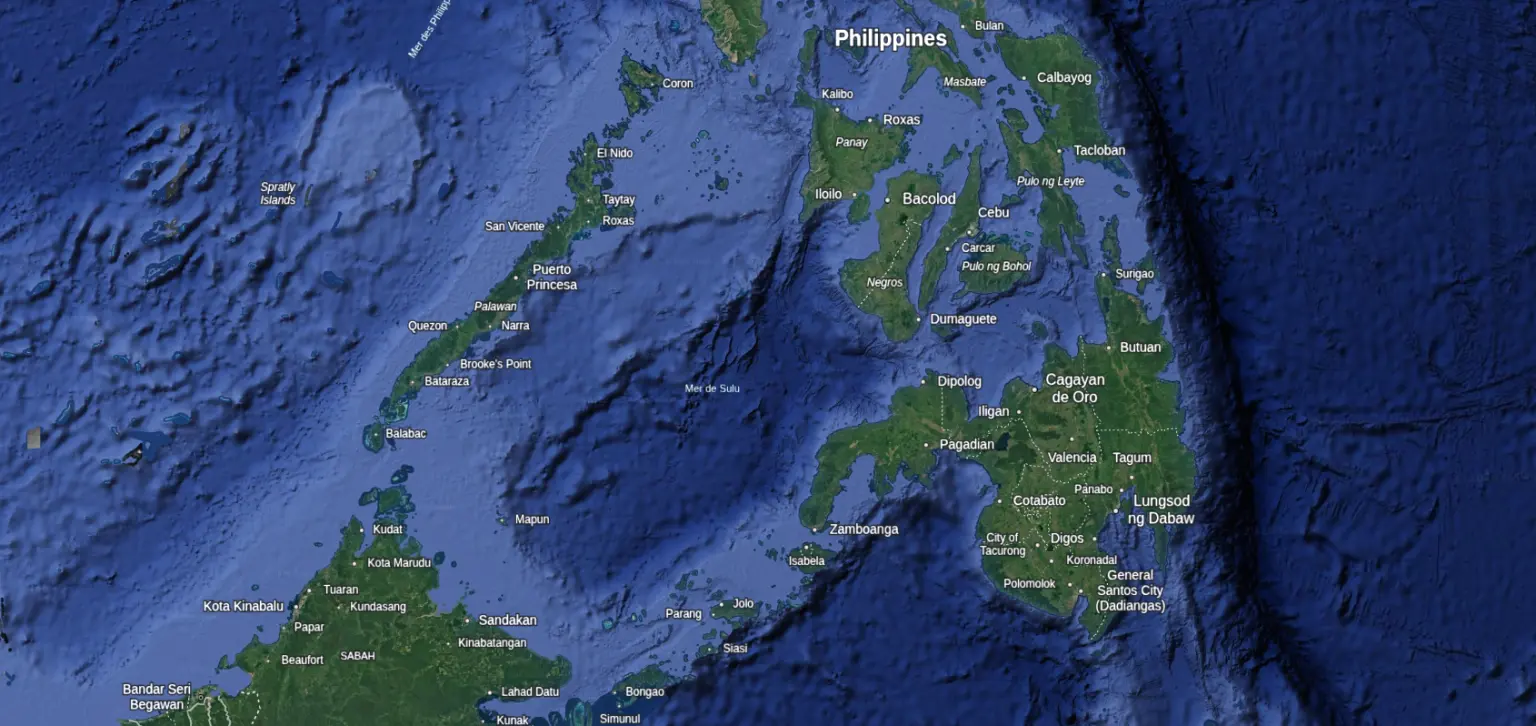
Sulu Sea — 7.52245°N, 117.67676°E
summit −19 m
If an advanced pre-Younger Dryas civilisation existed, where was its centre?
The hypothesis of a pre-Younger Dryas civilisation has been explored from many angles: the Silurian Hypothesis (Frank & Schmidt 2018), the archaeological anomalies, the converging mythological traditions. But if we take the idea seriously for a moment, a very concrete question follows: where would we look for the centre?
Since the Last Glacial Maximum, sea levels have risen 120 metres. Any coastal civilisation predating the Younger Dryas catastrophe (12,800 years ago) would now be underwater. The archaeological record on land is necessarily incomplete. So the question becomes: is there a computational way to narrow down a location, using the evidence that does survive?
That's what we tried. We took the anomalous sites that share a common signature (piezoelectric materials, Φ-ratio geometry, acoustic resonance, proximity to geological faults) and asked whether they point somewhere. The answer surprised us.
Archaeological anomalies
The archaeological record already contains anomalies that raise questions worth investigating:
9,600 BCE
Göbekli Tepe
50-tonne monoliths erected by hunter-gatherers, at a date that coincides precisely with the end of the Younger Dryas.
~100 BCE
The Antikythera Mechanism
A 1,400-year gap between this device and the next comparable technology.
Multiple eras
Giza, Baalbek, Kailasa, Delhi Pillar
Precision and scale that each require separate explanations.
A common signature links these anomalies: Φ-ratio geometry, proximity to geological faults, piezoelectric building materials, mercury deposits, acoustic resonance properties. One model explains what currently requires seven or more separate hypotheses.
Four independent pillars
We developed a computational pipeline to test whether converging signals point to a specific location. The investigation rests on four independent pillars, each using different data, different methods, and different assumptions. The methodology is detailed in a preprint (Sivan, 2025) open for review.
Pillar I
Geometry
A network of 8 megalithic sites falls on concentric Φ-ratio shells converging on a single point in the Sulu Sea (7.550°N, 117.750°E), with a fit of ±2%. The same sites align on a great circle with R² = 0.9998 (z = 4.98, p < 10⁻⁶).
We ran a Monte Carlo audit with 50,000 random control corpora. The original Bayes Factor (200-500) was retracted when the audit flagged overclaiming. The revised BF is 10-25 ("strong"). The geometric signal survived our own attempt to destroy it.
Pillar II
Bathymetry
At the convergence point sits GEBCO Hill: an elliptical submarine feature (~5 km × 7 km), summit at −19 m (standard recreational dive), which at the Last Glacial Maximum stood 101 m above sea level.
The concentric ring pattern described in Plato's Critias matches the GMRT bathymetric profile with RMSE 6.2 m across 6 parameters. The plain dimensions show errors of +2.7% and +5.4%.
The hill has been confirmed by 6 independent detection methods (GEBCO, GMRT, ETOPO, satellite altimetry, Sentinel-2 SDB, ICESat-2). A gravimetric anomaly of +38 mGal (RV Sonne survey) indicates an igneous rocky basement, not a coral reef. Combined BF for physical existence of the feature: 25-80 (>99% probability that the relief is real).
Pillar III
Ancient texts
35 annotations from Plato's Critias were systematically tested against the site. None produced a contradiction. Three philological keys proved decisive: the mobile Pillars of Heracles (Egyptian reference frame, not Gibraltar), the 180° directional inversion (Egyptian-to-Greek transmission), and the pélagos/pontos/kolpos maritime vocabulary that maps precisely onto the Sulu Sea geography.
Combined philological Bayes Factor: BF 11-17.
Pillar IV
Nazca convergence
Two independent geodesic alignments from the Nazca Lines (T3 and Cyclopean wall) converge on P6 with p = 0.00017. This analysis is external to the ALBA corpus: the Nazca data comes from the Nazca Group's published Table-8, and the convergence was computed independently of the geometric pillar.
Supporting indicators
Beyond the four load-bearing pillars, several converging indicators reinforce the hypothesis without being strong enough to stand alone:
Mt. Kinabalu
Highest peak in maritime SE Asia (4,095 m), sheltering the site from north winds, consistent with the Critias description.
Sama-Bajau ancestry
Population genetics (Larena et al. 2021) document multiple migrations and a diasporic triangle centred on the Sulu Sea.
Flood myths correlation
Regional flood narratives correlate with bathymetric contours at statistically significant rates across maritime SE Asia.
Betelgeuse declination
Precession-corrected stellar alignment at ~15,000 BP is consistent with the Great Circle, providing an independent astronomical anchor.
Self-correction
When our Monte Carlo audit flagged overclaiming in the original Bayes Factors, we retracted them ourselves and published the correction. The combined BF across all four pillars is 50-200 ("very strong"), revised down from the initial 250-1,500 ("decisive"). The signal survived, but the confidence language changed.
The site
Current Bayesian state (revised v2): P(H₃) = 71–86% before fieldwork. The combined Bayes Factor across all four pillars is 50-200 ("very strong"), revised down from the initial estimates after Monte Carlo audit. Whether the convergence reflects a genuine archaeological signal or a statistical artefact is precisely what fieldwork would determine.
Preprint: Sivan, J. (2025). A Bayesian Search for a Pre-Younger Dryas Non-Industrial Civilisation. Zenodo DOI: 10.5281/zenodo.18607785. CC-BY 4.0.
The Expedition: Three Phases
Days 1–5
High-resolution acoustic survey. Multi-beam echo sounder, side-scan sonar, sub-bottom profiler.
First sub-metre bathymetric map.
Days 6–9
ROV investigation of deep zone (−83 m). Video transects, sediment sampling, search for worked stone.
Direct visual inspection beyond diving depth.
Days 10–14
Direct human investigation of summit (−19 m). Photogrammetric documentation, rock sampling.
Human eyes on the predicted acropolis.
What will we find?
Bronze
Complete bathymetric map. Scientific value regardless of outcome.
Silver
Geometric anomalies. Non-natural patterns confirmed by sonar.
Gold
Datable artefacts. Worked stone or material culture.
Platinum
Pre-Holocene structures. Verified by independent teams.
"Even Bronze advances science. Whatever we find, the data is published."
Reading Plato
Could this hill be Atlantis?
We weren't looking for Atlantis. The geometric and bathymetric pillars identified GEBCO Hill before we ever opened the Critias. But when we realised the coordinates fell in the area described by Plato's texts, we decided to run the test properly.
We translated and annotated the entire Timaeus (20d–25e) and Critias (107a–121c) word by word, and tested every claim systematically against GEBCO Hill. 35 annotations. None produced a contradiction.
Three philological keys
The text contains three corrections that transform impossibilities into correspondences:
Key #1: The Pillars of Heracles were not fixed at Gibraltar
Plato's own text signals this: the Egyptian priest uses a phrase ("as you yourselves say") indicating he used a different reference. Historical analysis shows the Pillars were a mobile concept until Eratosthenes (~250 BCE) fixed them at Gibraltar. In earlier Greek and Latin tradition, the terminology extended to the Indian Ocean passage (Bab el-Mandeb).
Key #2: The Egyptian 180° directional inversion
In the ancient Egyptian cartographic system, south = "front" (resut) and north = "behind" (mehet). The information chain (original event → Egyptian oral tradition → priests of Saïs → Solon → Plato) preserves the inversion without anyone correcting it. Applied to the Critias: "mountains to the south protecting" becomes Mount Kinabalu (4,095 m) to the north of P6. "Open plain toward the north" becomes the Sulu Sea opening southward. Every direction resolves.
Key #3: Pélagos / pontos / kolpos
Plato uses three distinct Greek words for bodies of water, each with a precise meaning. When read correctly, they describe an archipelagic maritime structure, not an open Atlantic Ocean.
What the Greek reveals that translations hide
πηλος βραχυς
Timaeus 25d
Translated as "mud" or "shoals" depending on the edition. The Greek literally means "very shallow clay-bottom": an exact description of a submerged continental shelf. Not a swamp. Not silt. Shallow water over a flat bottom.
ταφρος vs διωρυξ
Critias 115d
Two different words for "canal", encoding two levels of hydraulic infrastructure: a major excavation (ταφρος, the 50-stade canal to the sea) and secondary distribution channels (διωρυχες). D8 flow-accumulation analysis of Sundaland at LGM reveals exactly this hierarchy.
φυσει και υπο βασιλεων
Critias 118c
"By nature and by kings." The concentric rings were partly natural, partly engineered. On an ophiolite hill, basalt plateaus and serpentinite slopes produce natural terraces. The kings completed what geology began. This resolves a puzzle that stumps every flat-terrain candidate.
A geology lesson in three colours
Plato says the Atlanteans quarried three colours of stone from the hill itself: white, black, and red (Critias 116a–b). This is a geological signature: the ophiolite sequence. In Sabah, a single formation (the Darvel Bay ophiolite) produces exactly this triad:
| Plato's colour | Rock type | Present at Sabah |
|---|---|---|
| λευκος (white) | Limestone | Massive karst formations (Gomantong, Madai) |
| μελας (black) | Serpentinite / basalt | 3,500 km² of ultramafic outcrops |
| ερυθρος (red) | Radiolarian chert / laterite | Documented in the Darvel Bay ophiolite |
GEBCO Hill sits on the offshore extension of this ophiolitic belt. Most competing candidates (Mediterranean, Atlantic) cannot produce this three-colour signature from a single geological formation.
Endemic fauna
The Critias mentions elephants (115e) and sacred bulls hunted "without iron" (119d). Borneo has both: the pygmy elephant (descended from Stegodon) and the banteng (Bos javanicus lowi), a wild bovid endemic to Sabah. No other candidate site hosts native populations of both large mammals.
The dimensions
Every physical dimension Plato gives was tested against GEBCO and GMRT bathymetry, using the standard Attic stade (185 m) with no optimisation:
| Parameter | Plato | Measured | Error |
|---|---|---|---|
| Central island diameter | 2.5 stades | 461 m (2.49 st) | −0.3% |
| Ring widths (5 rings) | 1:2:2:3:3 | GMRT radial profile | RMSE 6.2 m |
| Total ring radius | 13.5 stades | 2,499 m (13.51 st) | +0.0% |
| Great Plain, long axis | 3,000 stades | 570 km (3,081 st) | +2.7% |
| Great Plain, short axis | 2,000 stades | 390 km (2,108 st) | +5.4% |
| Canal to sea | ~50 stades | ~47 stades (GMRT) | −6% |
Six quantitative parameters from a 2,400-year-old text reproduced at ±3.3% accuracy in the submarine topography. This is, to our knowledge, the most precise textual-geographic correspondence ever documented for any candidate site.
Our Commitments
Publish everything
CC-BY 4.0, raw data, no selective reporting.
UNESCO compliance
Convention on Underwater Cultural Heritage (2001).
Accept refutation
If negative, publish and update probabilities.
What would prove us wrong
- High-resolution sonar shows only natural formations
- Sediment core with no anthropic markers
- Geometric patterns absent at sub-metre resolution
Get Involved
Researchers
Marine archaeologists, geologists, bathymetric specialists.
Dive Professionals
Dive masters, ROV operators, sonar technicians.
Media
Documentary producers, science journalists.
"The investigation began with a question. It produced coordinates, methodology, and a site at diving depth. The only step left is to go and look."
The evidence demands investigation.
The data is published. The site is at diving depth.